

For various reasons, the Teesta River is currently in a state of crisis. There is general consensus that a massive initiative (a mega-plan) is required to resolve this crisis. However, the debate lies in determining what kind of mega-plan is actually needed. This question is the central theme of this essay. To solve the Teesta crisis, a company called Power-China has formulated a project titled the “Teesta River Comprehensive Management and Restoration Project,” which is commonly known as the “Teesta Mega-Plan.” The question is—can this project provide a solution to the Teesta crisis, or is a different kind of mega-plan required?
To explore this question, the first part of this essay discusses the two general approaches that can be taken toward rivers and which of them is more suitable for Bangladesh. The second part of this serialized essay will explain how the Teesta crisis originated. The third part will present the history and true nature of the Teesta mega-plan prepared by Power-China. The fourth part will discuss seven unresolved questions regarding this project. In light of these unresolved questions, the fifth part will present some proposals for a potential alternative mega-plan. Finally, the sixth part will propose a constructive method to resolve the debate over the appropriate mega-plan for the Teesta.
1. Two Approaches Towards Rivers
1.1 Two Roles of Rivers
Rivers have two types of roles. One is natural (ecological), and the other is economic. The natural role has two aspects. The first is to maintain the earth’s water cycle (hydrological cycle). For example, ocean water evaporates, is carried by the wind over land, rises when obstructed by mountains, cools, and falls back down as rain and snow. Rivers bring this water back to the sea, thus continuing the water cycle. The second aspect of a river’s natural role is that rivers build distinct natural ecosystems in their respective basins. Civilizations are built upon these ecosystems. For this reason, rivers are a primary source of the earth’s geographical diversity.
Alongside their natural roles, the economic role of rivers is also crucial. Rivers provide fish for human consumption, act as a medium of transportation, and supply water for irrigation, among other things. In short, rivers serve as an economic resource for human society. This dual role of rivers—natural and economic—existed in the past and continues today. Both roles are important. Therefore, in utilizing a river as an economic resource, determining whether its natural role is being destroyed in the long run is a critical factor in river-related policymaking.
1.2 The Emergence of the Commercial Approach to Rivers
Before the Industrial Revolution, human societies did not heavily interfere with rivers. The primary reason was technological limitations. Human societies at the time lacked the technology required for massive interventions. Consequently, they allowed rivers to remain in their natural state and reaped the economic benefits without disrupting them. As a result, the natural role of rivers was not hindered. This approach toward rivers can be termed the “pre-industrial nature-based approach.”
However, this situation changed over time. The “discovery” of the New World in the sixteenth century initiated a commercial revolution, which gradually created the preconditions for the Industrial Revolution. The first Industrial Revolution began in England in the late eighteenth century. The Industrial Revolution elevated human society to a new technological tier. Through the invention of mechanical power, humans overcame the limitations of muscle power. Consequently, human society gained the technological capability to intervene heavily in rivers.
The emergence of commercial goals on one hand, and the acquisition of the technological capability to intervene in rivers to achieve these goals on the other, led to the birth of the “commercial approach” to rivers. The core premise of this approach is: “Allowing river water to flow into the sea is a waste!” In other words, all river water must be sucked up and used for various commercial purposes. Needless to say, from this perspective, the natural role of the river is completely denied; the river is viewed solely as an economic resource, and all forms of intervention on the river are encouraged to exploit this resource.
1.3 Two Forms of the Commercial Approach
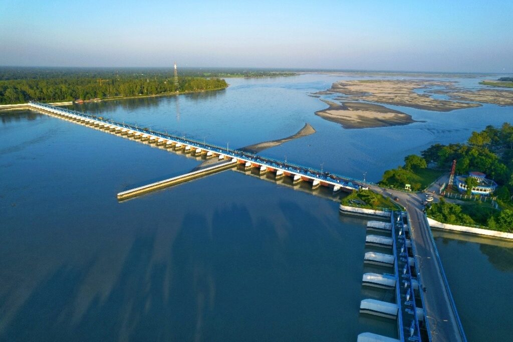
Human intervention in rivers has taken two forms. One is frontal (transverse) intervention, such as the construction of cross-dams. The Kaptai Dam, built in the 1960s on the Karnaphuli River in Bangladesh, is one such example. These dams essentially halt the open flow of water. Another form of frontal intervention is a gated dam (barrage). The Teesta Barrage, built on the Teesta River in Bangladesh in the 1980s, is an example. While river water can flow through a barrage, this flow can be restricted or even completely stopped at will by controlling the gates. There are other forms of frontal interventions as well. The main objectives of such interventions are power generation, water supply for irrigation, urbanization, and industry, river flow control, and the creation of reservoirs for recreation.
The second type of intervention on rivers is lateral intervention. The construction of riverbank embankments is one such intervention. In Bangladesh, such embankments are usually called ‘beribadh’. The “Brahmaputra Right Bank Embankment” is an example. Another example of lateral intervention is a flood wall. Flood walls are often built on top of previously constructed embankments, like those built over parts of the embankment in the Dhaka-Narayanganj-Demra project. Another example of lateral intervention is “channelization” (river straightening). Later, we will see that Power-China’s Teesta mega-plan is essentially this kind of project. The ultimate form of lateral intervention is “canalization,” where both sides and the bottom of a river are paved with cement. The Los Angeles River in the United States has been transformed into such a paved canal. Fortunately, no such project has been proposed in Bangladesh yet.
1.4 The Lateral Form of the Commercial Approach – The Cordon Approach
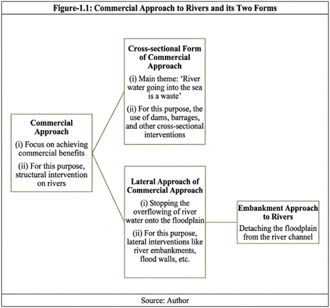
In light of the two types of interventions described above, the commercial approach to rivers also takes two different forms (Figure 1.1). One is the frontal form, and the other is the lateral form. The lateral form of the commercial approach is referred to as the “cordon approach.” This is because the main objective of these lateral interventions is to isolate (cordon off) the floodplains and tidal plains from the river channel so that river water cannot overflow into them during the monsoon. It is believed that this will increase the commercial value of the floodplains, as more crops can be grown and various expensive infrastructures can be built on these lands. In this essay, the term “commercial approach” will be used in two senses. One is the broader sense, meaning both its frontal and lateral forms. The second is the narrower sense, meaning only its frontal form. (The specific context will make it clear which sense is being used).
It is notable that frontal interventions are usually seen more in the upstream areas of rivers. Because rivers flow through mountains in these areas, they have a steeper gradient, which facilitates power generation. The mountains also make it easier to build reservoirs through frontal intervention. On the other hand, lateral interventions are more common in the middle and downstream sections of rivers, where rivers flow through floodplains and tidal plains, and these interventions are used to prevent river water from overflowing.
1.5 The Global Spread of the Commercial Approach
Given the history described above, it is no surprise that the commercial approach to rivers first gained traction in England and the Western European countries that industrialized first. However, in the late nineteenth and early twentieth centuries, the commercial approach advanced aggressively in the “New World,” including the United States, Canada, and Australia. From the second half of the twentieth century, the commercial approach spread to developing countries as well. In particular, China and India moved forward very actively in building dams and barrages. There are currently about 50,000 large dams globally, with about 20,000 in China and about 10,000 in India. China is currently playing an active role in building dams in other developing countries as well.
Lateral intervention on rivers, or the cordon approach, also first advanced in the industrialized nations of Europe. However, in the twentieth century, the United States took the lead in this regard. The levees built on both banks of the Mississippi River in the US are recognized as some of the largest river embankments in the world. In the second half of the twentieth century, the cordon approach aggressively advanced in the developing world too. India, in particular, demonstrated significant activity in this area. China has also built numerous riverbank embankments. China’s Huang He (Yellow River) is particularly notable in this regard. China had built embankments on both banks of this river in the Middle Ages. However, later—especially after the 1949 revolution in the New China—these embankments were further expanded and fortified.
1.6 Cordon vs. Polder
While the term “cordon” might be new to many Bangladeshi readers, they are familiar with the word “polder”. This is because the roughly 140 cordons built along the coast of Bangladesh are generally called polders. The term and concept of the polder originated mainly in the Netherlands. About 20 percent of the Netherlands’ land is below sea level, and these lands were reclaimed from the sea by building embankments around them. Many of these embankments are directly adjacent to the sea; the rest are adjacent to rivers. Most of the cordons built along the coast of Bangladesh are of this type, meaning they have embankments on all four sides, although they were not built to reclaim land from below sea level. Rather, their main purpose was to prevent the intrusion of saline tidal water. The difference between a polder and a cordon is that not all cordons require embankments on all four sides. That is, one or more sides of the cordoned land may not have a river, or even if there is, the land elevation there might be above the flood level, making embankments unnecessary on those sides. Many cordons in Bangladesh are of this type. In short, all polders fall within the category of cordons, but not all cordons are polders.
1.7 Various Consequences of the Commercial Approach
Interventions following the commercial approach to rivers achieved some initial successes. For example, electricity is generated by dams; reservoirs created by dams make it possible to irrigate many lands; and necessary water can be supplied for many cities and industries. However, the negative consequences of these interventions soon became apparent. For instance, while cross-dams can generate hydroelectricity, they also fragment the rivers; their dynamic character is destroyed; the free movement of various aquatic creatures living in the river is hindered; and numerous adverse reactions occur on the riverbed both upstream and downstream of the dam. Multiple cross-dams have been built on many rivers, turning them into staircases of stagnant reservoirs instead of flowing watercourses. In many cases, cross-dams and barrages have impaired the transportation role of rivers. Through commercial intervention, so much water has been drained from many rivers that there is no water left to reach the sea. As a result, their deltas are drying up and gradually shrinking due to the onslaught of the sea. Sea-level rise due to climate change is accelerating this process of decay and disappearance of the deltas.
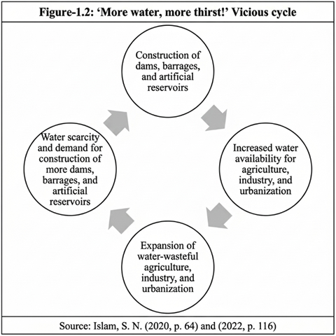
Research shows that the benefits achieved through commercial approach interventions have brought many disadvantages alongside them. For example, the water obtained from dam-created reservoirs has spread wasteful irrigation practices; it has created waterlogging and salinity, damaging land quality in the long term. From an economic perspective, this irrigation has not been efficient. The easily available water from dam reservoirs has promoted unsuitable agriculture, spurred urban expansion in unsuitable locations, encouraged water-wasting lifestyles, and consequently multiplied water demand, leading to water crises. Thus, dams have given birth to a vicious cycle of “More water, more thirst!” (Figure 1.2).
Furthermore, the claim that hydroelectricity is renewable has not proven entirely correct. Firstly, dams have a specific lifespan, after which they cease to function. It is impossible to build new dams in their place because the nature and course of the river at that location have already changed. Secondly, reservoirs created by dams produce various greenhouse gases (GHGs), specifically methane gas, which has a much higher global warming potential than carbon dioxide. Thus, dam-generated electricity is not as favorable for preventing climate change as is often claimed. Over time, these reservoirs fill up with silt and sand; consequently, the power generation and irrigation capacity of the dams decrease, and the cost of dam-generated power and irrigation increases. In fact, reservoirs filling up with silt is one of the reasons a dam’s lifespan comes to an end. In light of these various experiences, doubts have arisen regarding the effectiveness of continuously increasing cross-interventions to use rivers as economic resources.
1.8 Various Consequences of the Cordon Approach
Similarly, questions have arisen about the effectiveness of lateral interventions on rivers aimed at increasing the commercial use of floodplains. Experience shows that riverbank embankments increase flood damage rather than reduce it. One reason is that these embankments encourage settlements and infrastructure construction below the flood line in the floodplain. Consequently, if the embankment breaches for any reason, massive devastation occurs. In other words, in trying to prevent normal flooding, the cordon approach invites catastrophic floods. Residents inside the embankments then demand the construction of even higher embankments. This gives rise to a vicious cycle of “building higher embankments from lower ones” (Figure 1.3).

Moreover, these embankments prevent the silt-laden monsoon water from entering the floodplains. Consequently, the floodplains are deprived of silt; the process of land building is hindered; floodplains suffer subsidence; and this further exacerbates the severity of catastrophic floods. Being deprived of silt-laden monsoon water reduces the fertility of the floodplains, increases reliance on chemical fertilizers, and subsequently increases pollution. Wetlands located in the floodplains cannot be renewed, and the groundwater recharge rate decreases. The floodplain environment faces degradation.
1.9 The Emergence of the Nature-based Approach
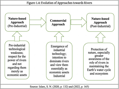
In light of the above experiences, the “nature-based approach” emerged as an alternative to the commercial approach. In this approach, the economic role of rivers is not denied; but importance is placed on ensuring that interventions to use rivers as economic resources do not destroy their fundamental natural roles. This modern-era nature-based approach can be termed the “post-industrial nature-based approach”.
It is noteworthy that although the post-industrial nature-based approach is ideologically similar to the pre-industrial nature-based approach, a crucial difference exists between the two. As mentioned earlier, the primary reason for the pre-industrial nature-based approach was technological limitations. At that time, human society lacked the technology to make such massive interventions that would destroy the core natural role of rivers. From this perspective, the context of the post-industrial nature-based approach is exactly the opposite. A low level of technology is not the cause of this approach; rather, it could be said that the excessive development of technology has given rise to this approach. Technology has reached such an advanced level today that it is possible for humans to tame even massive rivers. However, from experience, humans have become aware of the negative consequences of suppressing rivers and have voluntarily decided to refrain from major interventions. Therefore, whereas the pre-industrial nature-based approach was a necessity for humans due to a low level of technology, the post-industrial nature-based approach is an optional decision [1]. According to the German philosopher Hegel’s theory, this can be viewed as an example of the “negation of the negation” process (Hegel 1991). From the perspective of this theory, the transition from the pre-industrial nature-based approach to the commercial approach was the first negation, and the transition from the commercial approach to the post-industrial nature-based approach is the second negation (Figure 1.4). As a result, humanity is returning to the original state, but on the basis of superior technology and consciousness. This is the negation of the negation, which is a common characteristic of the process of continuous progress.
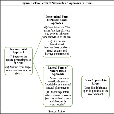
1.10 Two Forms of the Nature-based Approach
Like the commercial approach, the nature-based approach also has two forms. One is its frontal form, which discourages frontal interventions on rivers. The other is its lateral form, which discourages lateral interventions on rivers (Figure 1.5). The lateral form of the nature-based approach is briefly called the “open approach,” as its core message is: floodplains must be kept open to the river channel so that the river’s silt-laden water can reach the floodplains and tidal plains. Clearly, the frontal form of the nature-based approach is more applicable to the upstream portions of rivers, as they flow through mountains there, providing more opportunities for cross-interventions. Conversely, the lateral form of the nature-based approach, or the open approach, is more applicable to the middle and downstream portions of rivers, as they flow through floodplains and tidal plains there.
1.11 The Spread of the Nature-based Approach
Like the commercial approach, the nature-based approach first emerged and developed in the countries that industrialized first. Over time, movements against the construction of cross-dams and barrages grew in these countries. As a result, the construction of many new cross-dams was halted. In addition, many old cross-dams were removed. An attitude against lateral embankments also developed in these countries, leading to decisions to open up previously cordoned floodplains. River restoration processes progressed accordingly by removing cross-dams and completely or partially breaching lateral embankments to open the floodplains. The “Water Framework Directive” (EU 2000) adopted in 2000 and the “Floods Directive” (EU 2007) adopted in 2007 by the European Union served as significant milestones advancing the nature-based approach in Europe. A 2016 report by the European Environment Agency further reinforced this journey (EEA 2016). In 2006, the Netherlands government adopted a new policy called “Room for the River,” under which more space was opened up for the country’s rivers. To this end, lateral river embankments in many places were moved further back from the riverbanks; some floodplains were opened for the river water to overflow; and “floodways” were constructed for this purpose. After the great flood of 1993 in the United States, decisions were made to create more breaches and floodways in the Mississippi River embankments to allow the river water to spread over more floodplains. [2]
The nature-based approach towards rivers is now expanding into developing countries as well. In a sense, developing countries should have a more favorable environment for adopting the nature-based approach. Because these countries were largely in a pre-industrial state until recently and have not yet fully industrialized. Consequently, the legacy or remnants of the pre-industrial nature-based approach towards rivers should still exist in these countries. We see a reflection of this in various countries located in the Andean mountain ranges of South America, where indigenous people make up a large portion of the total population. A highly respectful attitude has spread in these countries not just towards rivers but towards nature as a whole. As a reflection of this, a philosophy called “Buen Vivir” has spread there, the core message of which is that human society must coexist by respecting nature, not by destroying it. The highest expression of this attitude is seen in Ecuador’s constitution adopted in 2008, where a separate section titled “Rights of Nature” was added. This section states that, like humans, nature also has the right to live and flourish. Needless to say, as a vital, living part of nature, these rights apply to rivers as well. Similarly, we see that in New Zealand, due to the movement of the indigenous Maori community, the highly revered Whanganui River has been recognized as a living entity, and the Maori community has been appointed as its guardian to protect the river’s right to live and flourish as a living entity. Bangladesh, too, on February 3, 2019, recognized rivers as “living entities” and “legal persons” through a High Court verdict, granting the “National River Conservation Commission” the role of guardian to protect the rights of rivers. On August 6, 2020, the Supreme Court upheld this verdict. These various events provide evidence of the expansion of the nature-based approach towards rivers.
1.12 Nature-based Approach vs. Anthropocentric Approach
Regarding the relationship between nature and development, there is a debate between the anthropocentric vs. non-anthropocentric approach. The anthropocentric approach refers to a type of development where human welfare alone is considered the standard of development. The opposite is the non-anthropocentric approach, where the welfare of not just humans but other species is also taken into consideration when judging development success. There is no doubt that the commercial approach to rivers follows a narrow anthropocentric approach. To many, the nature-based approach to rivers might also seem to follow a narrow anthropocentric approach. However, from the discussion above, it is clear that the nature-based approach to rivers is also favorable to the interests of non-human species. It goes without saying that the nature-based approach is helpful for the conservation of aquatic biodiversity. Furthermore, as we noted above, this approach recognizes not just other living beings but even the rivers themselves as living entities. Therefore, it is incorrect to consider the nature-based approach as a follower of the narrow anthropocentric approach.
1.13 Nature-based Approach vs. Basin-based Approach
Another recommendation frequently encountered in discussions about rivers is the adoption of a basin-based perspective. This recommendation is particularly relevant when a river flows through multiple countries. In such cases, each country can claim sovereignty over the portion of the river within its borders and take steps accordingly that are harmful not only to other sharing countries but to the entire river. To avoid such consequences, all sharing countries are urged to adopt a basin-based approach so that each country makes decisions thinking about the entire river.
It is clear from the discussion in the preceding sections that the nature-based approach demands a basin-based perspective towards rivers. Since this approach encourages thinking of the river as a living entity, its followers should more acutely realize that what is done to one part of the river will affect the rest. It is noteworthy that so far, in most cases, recommendations for adopting a basin-based approach have mainly been made for the purpose of implementing the commercial approach towards rivers. That is, sharing countries are urged to negotiate with each other to build dams, barrages, etc., on their respective portions of the river rather than doing it in isolation for their own interests. Therefore, a basin-based perspective can also be used to apply the commercial approach to rivers. Ultimately, the core issue is whether the nature-based approach is being adopted towards the river. If that is achieved, adopting a basin-based perspective will also be ensured.
1.14 Pre-industrial Nature-based Approach in Bangladesh
Since time immemorial, the people of Bangladesh have followed a nature-based approach towards rivers. They never made any massive interventions in the rivers. In establishing settlements on this delta, they followed the formula of “excavation -> raising the plinth -> building homes.” That is, they first dug a pond; they used the excavated soil to raise a mound (plinth); and then they built houses and other structures on that elevated land. These ponds provided them with water for drinking and domestic use, supplied fish for food, and assisted in agricultural activities. They did not build any permanent frontal or lateral embankments. Consequently, the floodplains remained open to the rivers. They were also not very keen on building roads. They used boats during the monsoon and walked across the fields to reach their destinations during the dry season. Thus, there was no obstruction to water flow over the floodplains. However, to prevent riverbank erosion, direct river water deep into the floodplains, and facilitate transportation, they dug many canals, which are known as kata-khal (cut-canals). When necessary, they built cross-dams over small rivers and streams, but these were temporary. Particularly, to retain river water during the eight months of the year when rainfall is scarce, they built eight-month dams. In this way, they figured out suitable ways to live successfully in harmony with the rivers of this delta.
1.15 The Beginning of the Cordon Approach in Bangladesh: Krug Mission and the Master Plan
The first major intervention on the rivers and floodplains of Bangladesh occurred through the construction of railway lines by the British. The rivers of Bangladesh generally flow north-south. But in many cases, these railway lines proceeded east-west, transversely obstructing the water flow over the floodplains. Even where railways proceeded north-south, they obstructed the east-west flow of water over the floodplains. The obstruction created by railways was somewhat unintentional; and in cases where adequate numbers and lengths of bridges, culverts, etc., were maintained, this obstruction was somewhat minimized.
The conscious, government-level initiation of the cordon approach towards rivers in Bangladesh occurred in the 1950s. Toward the end of the British era, in 1943, many people died in a famine in undivided Bengal. Consequently, after the partition of the country in 1947, several international organizations stepped forward to assist in increasing food production in Bangladesh (then East Pakistan). The United Nations “Food and Agriculture Organization” (FAO) and the UN’s development lending agency, the International Bank for Reconstruction and Development (IBRD)—which later became better known as the World Bank—were particularly active. At that time, the commercial and cordon approaches towards rivers dominated in Western developed nations. Consequently, the lending agencies, dependent on the capital of these countries, were also followers of the commercial and cordon approaches. Since Bangladesh, like the Netherlands, is a delta, these international agencies relied heavily on experts from the Netherlands to determine water development approaches in Bangladesh. It is well known that the highest application of the cordon approach in the form of polders occurs in the Netherlands; as a result, these experts formulated various projects based on the cordon approach to increase food production in Bangladesh and moved forward with their implementation. [3]
Against this backdrop, the United Front won the election in 1954, and the East Pakistan government was formed under the leadership of Sher-e-Bangla A.K. Fazlul Huq. Around the same time, another Bengali leader, Huseyn Shaheed Suhrawardy, became the Prime Minister of the central government of Pakistan. Because popular Bengali leaders were in power, the moderate floods of 1955 attracted special government attention, and Prime Minister Suhrawardy sought UN assistance to resolve this flood problem. Responding to this request, the UN Technical Assistance Administration sent a delegation (mission) to Bangladesh in 1957. This mission was led by J.A. Krug, which is why it is known as the “Krug Mission.” Within a few months, the Krug Mission submitted an informative and analytical report to the Pakistan government regarding the water and power problems of Bangladesh. Two main recommendations were made in this report. One was to build a strong, autonomous organization for water and power development. The other was to appoint an international company as a consultant to formulate a plan for future water and power development in Bangladesh.
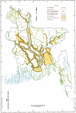
Following the Krug Mission’s recommendations, the East Pakistan Water and Power Development Authority (EP-WAPDA) was formed in 1959. It appointed the International Engineering Company (IECO), based in San Francisco, USA, as its consultant. In 1964, IECO formulated a Master Plan containing 51 water development projects. Most of these projects were based on the cordon approach. The Master Plan’s goal was to build embankments on both banks of all major rivers and their principal tributaries in Bangladesh so that monsoon water could not overflow into the floodplains. According to the Master Plan’s timeline, this overarching goal and all other projects were supposed to be implemented by 1985. Figure 1.6 shows what Bangladesh’s water development scenario would have looked like by 1985 if the Master Plan’s activities had been implemented.
1.16 Master Plan and the World Bank
A team from the World Bank reviewed the Master Plan. Based on this review, they characterized the Master Plan as a “polderization program” for a vast portion of Bangladesh. Generally, the World Bank supported the cordon approach toward rivers adopted in the Master Plan. However, they believed it was incorrect for the Master Plan to aim to build embankments on both banks of all large rivers and their main tributaries so quickly. Instead, the World Bank thought it was better to proceed in phases and proposed four phases for this purpose. In this context, the World Bank noted that generally, about two-thirds of Bangladesh does not flood.
Therefore, according to the World Bank, the goal of the first phase should prioritize increasing crop production in this part of the country. For that purpose, attention must be paid to utilizing the small-scale irrigation facilities available in these areas. The initiatives required in the second phase included: (a) building institutional frameworks; (b) data collection; (c) completing the implementation of ongoing projects; (d) initiating some pilot projects to figure out suitable solutions to the technical and institutional obstacles that would be faced in building embankments along large rivers; (e) appointing external consultants to assess the viability of those proposed large-scale projects that are safe from a hydrological perspective; and keeping embankments limited to only one bank for large rivers.
The goal of the third phase would be to continue the activities identified for the second phase and, if EP-WAPDA acquired the necessary capacity, begin implementing prioritized projects. However, projects involving embankments had to be geared solely towards flood control, not irrigation. Because further experience, data, and support were needed to determine how much large-scale gravity-based irrigation projects were required for the country’s mid-term development.
The tasks of the fourth phase would be to acquire the technical and institutional capability needed to implement large-scale projects based on the studies, pilot projects, data collection, and experience gained during the second and third phases. Once this goal was achieved, it would be possible to proceed with implementing the large-scale projects of the Master Plan, but it had to be done over a longer timeframe and with opportunities for necessary revisions.
To strengthen the data and logic behind their recommendations, the World Bank initiated a massive study of Bangladesh’s land and water resources in 1970. This study was completed in 1972, and a ten-volume report titled “Land and Water Resources Sector Study” was published based on it. This World Bank study showed that there are water resources for small-scale irrigation work almost everywhere in Bangladesh.
1.17 Implementation of the Cordon Approach
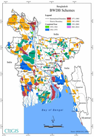
It was impossible for the government to ignore these World Bank recommendations. Firstly, there was data and logic supporting their recommendations. Secondly, the World Bank was one of the major funding institutions for water development efforts in Bangladesh. Therefore, for that reason as well, the government had to largely accept the World Bank’s recommendations. Consequently, the implementation of Master Plan projects involving the construction of embankments on both sides of large rivers and their branches was postponed. But the implementation of the other cordon approach-based projects of the Master Plan went ahead, and over time, many more such projects were adopted and implemented. Every year, about twenty percent of the development budget was spent on implementing and maintaining various water development projects. Because of this massive activity, countless cordon projects have been implemented in Bangladesh. There is virtually no district or upazila in Bangladesh where a cordon project has not been built. There is no river worth mentioning in Bangladesh over which some control structure has not been built (Figure 1.7). In a word, Bangladesh is saturated with cordon projects. Nowhere else in the world has the cordon approach been so universally applied.
1.18 General Consequences of Applying Commercial and Cordon Approaches to Rivers in Bangladesh
The results of applying commercial and cordon approaches to the rivers of Bangladesh have not been auspicious. There are two main reasons for this: First, the extreme seasonality of river flow in Bangladesh. Second, the presence of huge amounts of silt and sand in the flow of Bangladesh’s rivers. Because of extreme seasonality, it is difficult to confine the massive flow of the monsoon solely to the river channel. Secondly, it is also against nature. Because it is the rule of nature that river water will spread over the floodplains during the monsoon, gradually raising the elevation of the floodplains through silt deposition. Defying this rule through the adoption of the cordon approach has caused damage to river channels, floodplains, and tidal plains throughout the country.
Another consequence of the cordon approach has been waterlogging. Embankments not only prevent river water from coming into the floodplains; they also hinder rainwater and water from other sources in the floodplains from draining back into the river. Over time, drainage sluice gates get clogged with silt and sand, initiating waterlogging that gradually takes on a massive and severe form. Tragically clear examples of this can be seen now in the southwestern region of Bangladesh. For the coast, the consequences of the cordon approach have been even more tragic. By enclosing the entire coast within approximately 140 polders, siltation has not occurred there, and as a result, instead of rising, the land elevation inside the polders has decreased and is now below sea level in many places.
For these reasons, when Western development agencies attempted to forcefully reintroduce the cordon approach to the rivers of Bangladesh in the form of the so-called “Flood Action Plan” (FAP) after the floods of 1987 and 1988, resistance emerged from the people of Bangladesh. As a result, the FAP could not advance beyond its first phase. However, due to cognitive limitations and material interests, the attraction of Bangladeshi official circles to the commercial and cordon approaches remains ongoing. We see examples of this precisely regarding the ways to resolve the Teesta crisis.
Endnotes
[1] In one sense, the “post-industrial nature-based approach” is a necessity. Because if it is not adopted, the long-term sustainability of human civilization will face uncertainty.
[2] For further discussion on this, see: Islam, S. N. (2020, p. 257-258) and (2022, p. 186-192).
[3] Among these projects were the “Ganges-Kobadak Irrigation Project” (briefly “G-K” Project); “Brahmaputra Right Embankment Project” (briefly “BRE”); “Dhaka-Narayanganj-Demra Irrigation Project” (briefly “DND” Project); “Chandpur Irrigation Project” (briefly “CIP”); and “Coastal Embankment Project” (briefly “CEP”). Among these, the Coastal Embankment Project was entirely a polder construction project on the sea coast like in the Netherlands, hence FAO’s involvement was higher in it. The purpose of the DND and Chandpur projects was also to build polders, although not on the coast, but inland. On the other hand, the “Brahmaputra Right Embankment Project” was primarily a flood control project. The World Bank’s involvement was higher in this project, DND, and Chandpur projects. Both the World Bank and FAO were involved in the G-K project.
Dr. Nazrul Islam
Professor, Asian Growth Research Institute
Former Chief of Development Research, United Nations
Founder, Bangladesh Environment Network (BEN)
The information presented here is an English adaptation based on the report published on Sarbojon Kotha.
