
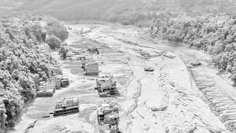
The sequence of catastrophic disaster events following a glacier collapse on Nepal’s northern border has sparked fresh, deep concern among environmentalists, geologists, and environmental scientists. Although it may initially appear to be a sudden local flood or landslide, in reality, it is not a single ordinary natural event. Rather, it is a dreadful and sequential cumulative reaction of multiple complex geological, meteorological, and environmental processes.
The event originated in an extremely remote and steep mountainous region along the Nepal-China border. However, such risks are not limited to a single specific local glacier; rather, structural instability is gradually accumulating across hundreds of glaciers spanning vast areas—from Kanchenjunga and the Everest region in the east, through the Annapurna mountain range, to Rasuwa Gadhi district.
According to observations by mountain scientists, these glaciers, located at altitudes of more than 5,200 meters above sea level, are direct victims of long-term global warming. In these regions, the subsurface layers of soil and rock frozen for thousands of years—known in geology as ‘permafrost’—have begun to melt internally due to continuously rising temperatures.
The excess moisture created by the melting of permafrost creates a slippery and uneven layer at the junction of the mountain wall and the glacier. As a result, the main foundation of the massive structure containing tens of millions of tons of ice and rock gets loosened.
As a consequence of this ongoing scientific process, one day a massive block of ice and a giant rock wall from the mountain face collapsed vertically downwards from an altitude of nearly 5,200 meters. This vast heap of ice and rock slammed into a narrow mountain valley located about 1,200 meters below. Due to the high altitude and under the influence of gravitational velocity, this sudden fall of thousands of tons of ice and rock generated an unprecedented impact of mechanical energy.
Under the impact of immense force, the vast glacier ice block—which had previously remained intact—shattered into small pieces in an instant. This massive debris of shattered ice and rock accumulated in the narrow gorge of the mountain valley, temporarily giving rise to a kind of artificial dam. Since mountain valleys are naturally narrow and deep, this temporary pile of ice and rock completely blocked the normal flow of the river. However, this artificial dam could not last long. The crushed ice fractured by the intense impact began to melt rapidly, turning into a vast volume of liquid water within a very short time. As a result, within just a few hours, the pressure of water and liquid ice behind the artificial dam exceeded its tolerance threshold, and the dam collapsed with explosion-like intensity.
After the collapse of the artificial dam, a mixture of tens of millions of cubic meters of trapped water, liquefied ice, massive boulders, sand, and mud began surging downwards at tremendous speed. In the terminology of geosciences and environmental science, this fast-moving, hyper-dense, devastating mixture of ice, rock, soil, and water is called a ‘debris flow’. This debris flow behaves much like the wet, dense concrete mixture used in modern building construction. It carries far greater density, weight, and destructive force than a normal water surge or flood.
This terrifying debris flow traveled a distance of over 200 kilometers at high speed down the steep, drain-like gorge of the mountain valley. Because the valley was extremely steep, the velocity of its flow kept continuously increasing. En route, when two major nearby mountain rivers—Bhote Koshi and Trishuli—merged into this valley, a vast volume of additional river water was added to it. With the addition of water from these rivers, the total volume, weight, and speed of this debris flow multiplied significantly—which later swept past the valley and violently struck the relatively flat and populated areas of the Narayani River basin. Roads, connecting bridges, houses, and various public and private infrastructure located there were washed away or turned into ruins in an instant by this torrent of ice, rock, and mud.
Such catastrophic debris flow events in mountainous regions are not entirely new. However, the unprecedented pace of climate change is making these occurrences far more frequent and severe than before. For instance, in 1970, triggered by an earthquake in the Andes mountains of the Latin American country Peru, a massive glacier collapsed in a similar manner, giving rise to a devastating debris flow. That catastrophic event resulted in the tragic deaths of over 22,000 people. Similarly, in 1999, a massive debris flow caused by torrential rain in Venezuela claimed nearly 30,000 lives. The terrible tragedy that occurred in 2013 in Kedarnath, Uttarakhand, India, was also primarily a catastrophic debris flow generated from cloudbursts and glacial lake outbursts. That single event claimed the lives of approximately 5,700 people.
The event in Nepal is a major and profound warning sign for the entire ecosystem of South Asia. However, according to various local media outlets in Nepal, including The Kathmandu Post, countries in the Himalayan basin, including Nepal, still rely heavily on conventional methods and mathematical averages for assessing disaster risks or forecasting. These countries must abandon traditional mindsets and modernize their glacier monitoring systems. It has become essential to utilize satellite data, conduct regular mapping of permafrost using drones, install real-time sensors and warning signals in every major steep river basin, and strengthen regional geographic data sharing.
Dr. Md. Khalequzzaman
Professor, Geology and Environmental Science
Commonwealth University of Pennsylvania, USA
Global Coordinator, Bangladesh Environment Network (BEN)
The information presented here is an English adaptation based on the report published on The Daily Samakal.