


For various reasons, the Teesta River has fallen into a crisis today. The debate over the master plan initiated to resolve this crisis revolves around what kind of master plan is actually needed. To solve the Teesta crisis, a Chinese company named Power-China has formulated a project called the ‘Teesta River Comprehensive Management and Restoration Project’, which is commonly known as the ‘Teesta Master Plan’. The question is—can this project provide a solution to the Teesta crisis, or is a different kind of master plan needed? To address this question, the first part of this essay presented which of the two approaches generally applied to rivers is more suitable for Bangladesh. In the second part of this continuously published essay, we explain how the Teesta crisis was created in the first place.
2. The Teesta River Crisis
2.1 Teesta River – A Brief Introduction
The Teesta River originates from the Pahunri (or Teesta Khangse) glacier at an altitude of about 7,068 meters in the Indian state of Sikkim. It flows south through various mountain gorges, and along the way, many tributaries join it, increasing its flow. At Sevoke in northern West Bengal, the Teesta River enters the plains from the mountainous region. It initially serves as a boundary between Darjeeling and Kalimpong, and then between Jalpaiguri and Cooch Behar districts. Flowing through Jalpaiguri district in India, the river enters Bangladesh and flows through Nilphamari, Lalmonirhat, Rangpur, Gaibandha, and Kurigram districts, eventually merging with the Brahmaputra River near Chilmari. The total length of the Teesta River is 414 kilometers, of which 133 kilometers are located in Bangladesh. The total catchment area of the Teesta River is 12,159 square miles; 83 percent of this is located in India and the remaining 17 percent in Bangladesh. However, almost half of the population of the Teesta basin (20 million) lives in Bangladesh.
The Teesta River is a ‘flashy’ river, meaning its flow suddenly decreases and increases. As it descends from the mountains to the plains, it has created an alluvial ‘fan’ at the foothills of the Himalayas. Because it is a flashy river, the Teesta’s course changes frequently. Figure 2.2 shows that previously, this river flowed southwards to merge with the Ganges River. However, in the 18th century, the river shifted its course to flow southeast and merged with the Brahmaputra River. There is disagreement over why this change occurred. According to many, as a result of the 1787 earthquake, the Brahmaputra River’s course shifted from flowing eastward (merging with the Meghna via the northeast side of the Madhupur Tract) to flowing directly southward (towards the present-day Jamuna River). According to this view, this earthquake also changed the direction of the Teesta River. According to another view, due to the 1787 earthquake or other geological reasons, the course of the Teesta River first changed from south to east and connected with the Brahmaputra, resulting in the latter’s flow changing from east to south. Regardless of the exact cause, the Teesta River’s course has changed many times in the past. Therefore, the possibility of it changing again in the future cannot be completely ruled out.
According to Bangladesh Water Development Board (BWDB) data, before the construction of the Gajoldoba barrage, the average dry season flow of the Teesta River at Dalia was approximately 283 cumecs (10,000 cusecs). However, during the monsoon season, this volume can reach 4,500 cumecs (158,918 cusecs). Teesta River water carries a huge amount of silt. It is estimated that the average annual amount of silt carried by the Teesta River is 49 million tons. This silt settles in various parts of the riverbed, creating shoals (chars), which has gradually turned the Teesta into a braided river. Compared to other rivers in Bangladesh, the Teesta River has a higher slope, approximately (1 ratio 2000). The width of the Teesta ranges from 0.7 kilometers to 5.5 kilometers (averaging 3 kilometers). As we have noted earlier, the Teesta has many branches and tributaries; meaning, the Teesta is not just a river, it is a river system.
2.2 Causes of the Teesta River crisis: India’s application of a commercial approach
The root cause of the multifaceted Teesta River crisis is the application of a commercial approach to this river. In this regard, the primary responsibility falls on India. We have noted earlier that India is one of the most aggressive developing nations when it comes to applying commercial approaches to rivers. Almost one-fifth of the world’s large dams are in India. India is not content with just building dams on individual rivers separately. Currently, India is advancing a massive project called the ‘Inter-river linking project’, the goal of which is to transfer water from the Brahmaputra and other eastern rivers to the west and south of India. India’s activities regarding the Teesta have become a part of this ‘Inter-river linking project’.
“The root cause of the multifaceted Teesta River crisis is the application of a commercial approach to this river. In this regard, the primary responsibility falls on India. We have noted earlier that India is one of the most aggressive developing nations when it comes to applying commercial approaches to rivers. Almost one-fifth of the world’s large dams are in India. India is not content with just building dams on individual rivers separately. Currently, India is advancing a massive project called the ‘Inter-river linking project’, the goal of which is to transfer water from the Brahmaputra and other eastern rivers to the west and south of India.”
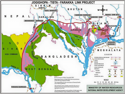
In 1987, India built and operationalized a barrage at a place called Gajoldoba, upstream from the India-Bangladesh border on the Teesta. India is not only using this barrage for irrigation within the Teesta basin, but the Teesta’s water is also being diverted eastward into the Jaldhaka and Torsha rivers, and westward into the Mechi, Mahananda, and Ganges rivers (Figure-2.1). Notably, the Indian government titled Figure 2.1 the ‘Jogighopa-Tista-Farakka Link Project’. Jogighopa is the name of the confluence where the Manas River (a major tributary of the Brahmaputra) meets the Brahmaputra. Thus, it is clear that through the Gajoldoba barrage, India is engaged in a grand endeavor to divert water first from the Brahmaputra to the Teesta, then from the Teesta to the Mechi-Mahananda, then from the Mahananda to the Ganges, and finally from the Ganges to the west and south of India.

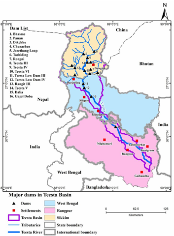
India is not merely satisfied with building the Gajoldoba barrage; it has built, is building, or is planning to build approximately 16 more dams upstream on the Teesta (Figure-2.2). Needless to say, once these dams are constructed, the Teesta crisis will deepen further, and there will be no Teesta water left for Bangladesh during the dry season.

2.3 Bangladesh’s application of a commercial approach to the Teesta River
Bangladesh also applies a commercial approach to the Teesta. As noted above, the commercial approach has two forms: the transverse (cross) form and the lateral form, which we call the ‘enclosure approach’. Though not as aggressive as India, Bangladesh also follows both transverse and lateral commercial approaches toward the Teesta.
2.3.1 Bangladesh’s Dalia Barrage on the Teesta
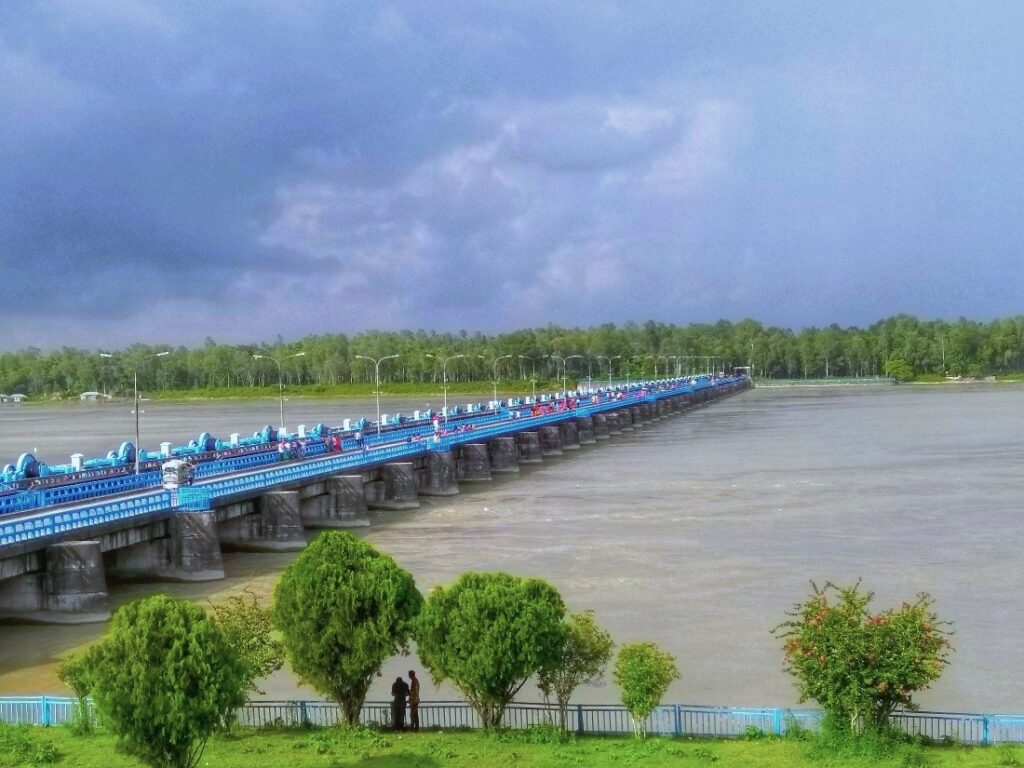
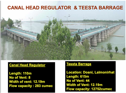
The symbol of Bangladesh’s transverse intervention on the Teesta is the Teesta Barrage built at Dalia. In the 1950s, the then-Pakistan government planned to construct a barrage on the Teesta River to increase irrigation and informed the Indian government about it. Accordingly, a foreign consulting firm conducted a pre-feasibility study in 1960. Later, in 1968-70, another foreign consulting firm prepared a report proposing the construction of this barrage at Dalia in Dimla upazila, 15 kilometers inside the border from India. However, the work did not progress much. Later, when India moved forward with the Gajoldoba barrage project, the work on Bangladesh’s Dalia barrage project was expedited. With the cooperation of engineers from the Bangladesh University of Engineering and Technology (BUET), the design of this barrage was finalized, and construction was completed according to it in August 1990 (two years after the Indian Gajoldoba barrage became operational). The size of this barrage was exceptionally large. With a total of 44 gates, each 12.19 meters wide, the total length of this barrage is 615 meters; and its total discharge capacity is 12,752 cumecs (450,146 cusecs), which is many times higher than the maximum flow observed in this river to date. To channel water downstream from the barrage for irrigation purposes, a 110-meter-long regulator with 8 gates, each 12.19 meters wide, was installed at the mouth of the canal, with a maximum discharge capacity of 283 cumecs (9,990 cusecs). A 45-hectare (111 acres) silt ‘trap’ was built at the canal’s mouth to catch sediment. Additionally, a 610-meter-long ‘flood bypass’ was built to discharge extra flow, and a 2,470-meter-long ‘closure dam’ was constructed to divert river water towards the canal (Figure-2.3).

According to the design of the Teesta Barrage Project, its total ‘command area’ is 749,000 hectares, of which 540,000 hectares are irrigable. This area stretches across the greater Rangpur, Dinajpur, and Bogra districts. North of this project area is the Teesta River; west is the Atrai River; south is the Santahar-Bogra railway; and east is the Bogra-Kaunia railway. Besides irrigation, flood control and drainage were additional goals of this project. The project was supposed to be implemented in two phases (Figure-2.4). In the relatively smaller Phase-I, the total command area was 182,000 hectares, out of which 111,406 hectares were to be brought under irrigation (specifically supplementary irrigation in the Kharif season). For this irrigation, a 307-kilometer-long Phase-1 canal; a 1,450-kilometer-long Phase-2 canal; a 2,735-kilometer-long Phase-3 (tertiary) canal; and 8,000 outlets were constructed. This extensive canal system was divided into three parts: ‘Teesta Canal System’, ‘Dinajpur Canal System’, and ‘Rangpur Canal System’. Phase-1 work began in December 1979 and was completed in August 1990. Construction of the barrage was completed at the same time. Irrigation utilizing this barrage and canal system began in 1993.
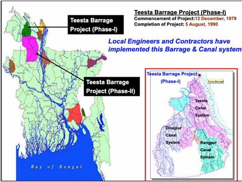
The second phase of the Teesta Barrage Project was approved at a meeting of the Executive Committee of the National Economic Council (ECNEC) in January 2004. The command area of this phase is 623,690 hectares, of which 448,774 hectares were to be provided with irrigation facilities. This second phase was further divided into three units, scheduled to be constructed during the periods 2003-2007, 2007-2010, and 2011-2013. In this phase, a total of 1,628 km of irrigation canals, 610 km of drainage canals, and 9,907 hydraulic structures of various types were to be built, including 2,025 for irrigation, 105 for drainage, 1,405 bridges and culverts, and 6,372 turn-overs. Additionally, the construction of 10 km of roads was included in the project’s second phase. To build all these physical structures, a plan was made to acquire a total of 5,400 hectares of land.
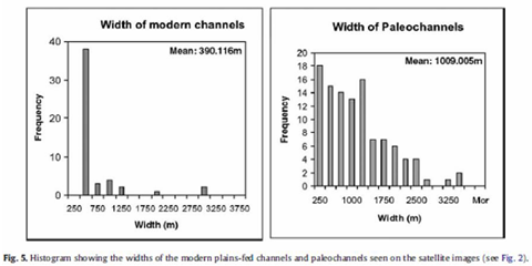
Ultimately, the irrigation scope of the Teesta Barrage Project was limited only to the relatively smaller first phase. However, by replacing the previously existing canals, streams, and rivulets with a newly constructed irrigation canal network in this area, the region’s capacity to hold monsoon water significantly decreased. Figure-2.5 shows that while the total length of the new channels is 1.2 times greater than the total length of the old channels, the average width of the old channels is approximately 2.6 times greater than the average width of the new ones. In other words, in terms of volume, the water retention capacity of the new channels has decreased by more than half compared to the old channels. We will return to this issue later.

Data points listed in original image text regarding irrigation area statistics
2.3.2 Bangladesh’s application of the enclosure approach on the Teesta
Bangladesh also applies an enclosure approach to the Teesta. The first instance of this occurred as part of the Brahmaputra Right Bank Project. As is well known, in the 1960s, a flood control embankment was built along the right bank of the Brahmaputra (Jamuna) River from Sirajganj in the south to Belka in the north. However, this embankment did not end at Belka. From Belka, it proceeded along the right bank of the Teesta up to Kaunia. As a result, a 39-kilometer stretch of the Teesta from Kaunia downstream to Chilmari was cut off from the right bank floodplain. Simultaneously, this section of the Teesta was effectively isolated from its right-side distributaries. The second instance occurred as part of the implementation of the Dalia Barrage Project, where embankments were built along the banks of the Teesta. At that time, an 80-kilometer-long riverside embankment and 10 kilometers of riverbank protection structures were built. Notably, the length of the Teesta from Dalia to the Brahmaputra is 104 kilometers. Therefore, it can be said that an embankment has been built along practically the entire right bank of the Teesta.
The application of the aforementioned commercial approaches inside Bangladesh on the Teesta resulted in multiple negative consequences. Firstly, even the small amount of Teesta water that enters Bangladesh after being diverted by the Gajoldoba barrage during the dry season is largely extracted by the Dalia Barrage for irrigation. As a result, the flow of the Teesta downstream of Dalia is further reduced. Secondly, as noted above, due to Bangladesh’s Teesta Barrage Project, the distributaries of the Teesta have been surrounded by embankments and practically cut off from the main Teesta River. Thirdly, the volume of the canals and streams that existed in the Teesta basin has been reduced by nearly half, consequently lowering the water retention capacity of the floodplains. Fourthly, due to the construction of embankments along the Teesta, both the Teesta riverbed and the Teesta floodplain have been damaged.
2.4 The Nature of the Teesta River Crisis
Due to India’s water extraction and establishment of control over the Teesta’s flow, alongside Bangladesh’s application of commercial approaches to the Teesta internally, the Teesta is currently in a multifaceted crisis. The main three aspects of this crisis can be identified.
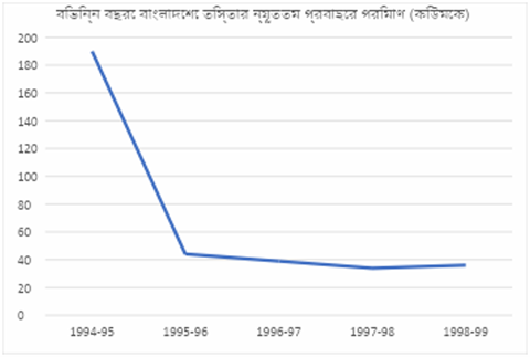
The most important aspect is the reduction of flow during the dry season (Figure-2.6). As a result, the Teesta River in Bangladesh now almost completely dries up during the dry season. Every river requires a ‘minimum environmental flow’, and if the flow drops below that, the river and the aquatic plants and animals dependent on it suffer permanent damage. Currently, the primary cause of reduced flow in the Teesta during the dry season is India’s upstream diversion of Teesta water.
“Due to India’s water extraction and establishment of control over the Teesta’s flow, alongside Bangladesh’s application of commercial approaches to the Teesta internally, the Teesta is currently in a multifaceted crisis. The main three aspects of this crisis can be identified.”

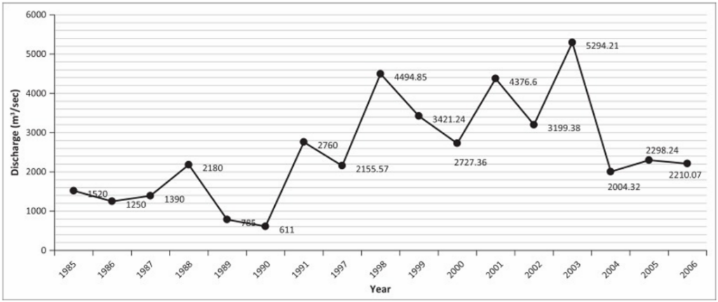
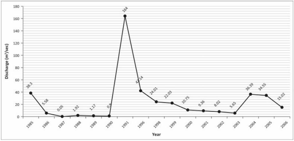
The second aspect of the Teesta crisis is monsoon flooding, coupled with an increase in the number and severity of flash floods. While India diverts Teesta’s dry season water, it opens the gates of its barrages during the monsoon season, releasing high flows toward Bangladesh (Figure-2.7 A, B); consequently, floods occur in Bangladesh during the monsoon. Flash floods have been added to this. Seasonal variations in river flows are already increasing due to climate change. Added to this is the water released from the reservoirs of India’s barrages. As a result, the frequency, duration, and intensity of flash floods are increasing.


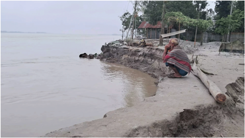
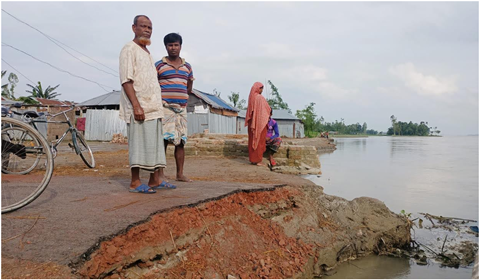
The third major aspect of the Teesta River crisis is bank erosion and unwanted changes and distortions to the river’s structural character. Since there is no water in the river during the dry season, more shoals (chars) form in the river, reducing its water-carrying capacity. Furthermore, during the dry season, the riverbed dries out and hardens, reducing the capacity to hold monsoon flows through bed erosion. Instead, the river attempts to accommodate the flow by breaking its banks and widening. As a result, the river simultaneously becomes shallower and wider. Riverbank erosion has now become the primary problem for the people living along the banks of the Teesta (Figure-2.8(A), 2.8(B)).


Dr. Nazrul Islam
Professor, Asian Growth Research Institute
Former Chief of Development Research, United Nations
Founder, Bangladesh Environment Network (BEN)
The information presented here is an English adaptation based on the report published on Sarbojon Kotha.
