

Global and regional factors are partly responsible for the current floods and waterlogging in Bangladesh, but the main cause lies in the various flawed policies followed internally. Bangladesh has been following these policies for almost 70 years. Consequently, it is not surprising that their accumulated consequences are manifesting severely now. Nazrul Islam writes about the solution to the increasing floods and waterlogging.

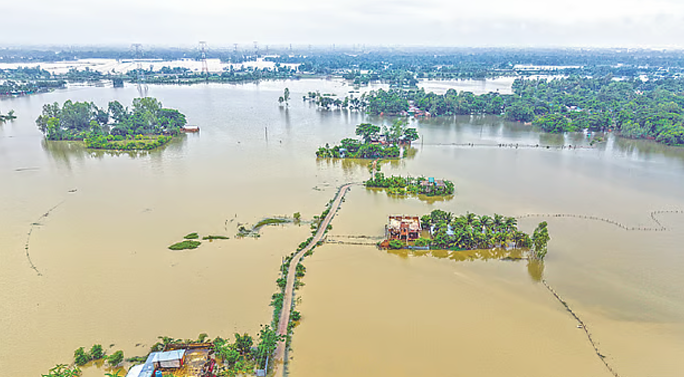
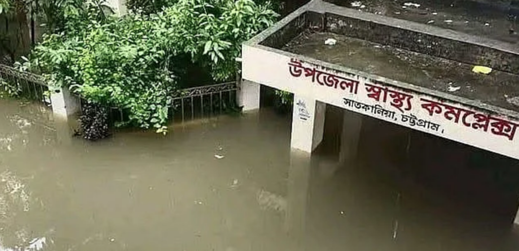
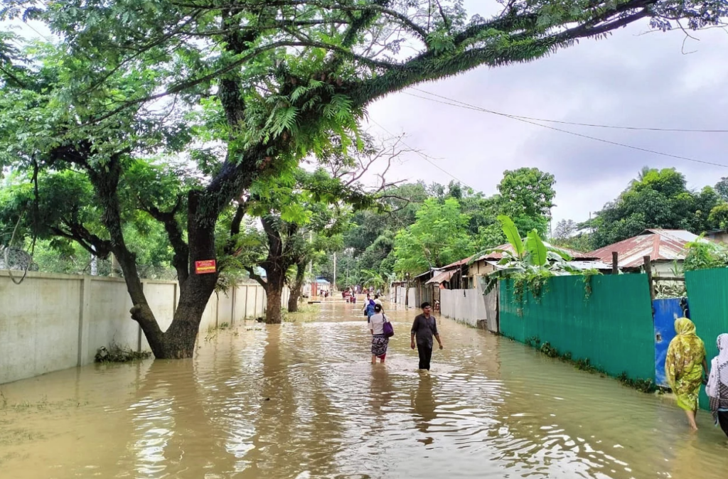
The country is floating in floods and waterlogging. In some places, these two problems have merged into one. The problem has become most severe in five districts of the Chattogram division. Among them are three districts of the Chittagong Hill Tracts—Khagrachari, Rangamati, and Bandarban. In addition, Chattogram and Cox’s Bazar. The Banshkhali, Satkania, Lohagara, and Chandanaish areas of South Chattogram have been specifically affected. The suffering in these areas is indescribable. A train on the widely utilized Dhaka-Cox’s Bazar line was stranded by floodwaters. The problem of massive flooding has also appeared in greater Sylhet.
Undoubtedly, the immediate priority is to stand by the affected people: saving their lives, making arrangements for them to survive until the water recedes, and assisting in rehabilitation afterward. Alongside this, some long-term thinking is also necessary. Why are the problems of floods and waterlogging gradually becoming so severe in Bangladesh? How can Bangladesh find a remedy for these two problems?
These questions need to be discussed deeply on a national level. Initiating that discussion is the purpose of this article.
Global Causes
The causes of the increasing floods and waterlogging can be broadly divided into two categories: global and internal.
The primary global cause is climate change. As a result, the sea level is rising; tidal waters are pushing further inland; consequently, instead of river water flowing into the sea, it is overflowing and flooding both banks. The sea level is rising all along the coast of Bangladesh; however, the rate is higher on the east coast. For example, while the annual sea-level rise on the western Sundarbans coast between 1985 and 1998 was 3.24 millimeters, the rate for Cox’s Bazar between 1978 and 1998 was 7.8 millimeters annually.
The second impact of climate change is the increase in the volume and seasonality of rainfall. Research shows that from 1948 to 2008, the annual average rainfall increased by 3.96 millimeters. However, the increase during the monsoon season alone was 2.05 millimeters, whereas during the winter it was only 0.2 millimeters. Furthermore, due to climate change, the frequency and severity of extreme weather events are also rising. These events include excessive rainfall occurring out of season or over very short periods, as well as an increase in the frequency and expanse of cyclones.
Bangladesh does not have much scope to mitigate these global causes. However, through adaptation, Bangladesh can lessen their impacts. We will return to how this is possible later.

Internal Causes
A major reason for the increase in floods and waterlogging in Bangladesh is the flawed policies adhered to within the country. In the 1950s, foreign lending agencies and consultants imposed the ‘cordon approach’ regarding rivers upon Bangladesh. The core of this approach is to isolate floodplains and tidal plains from river channels through the construction of embankments.
Foreign consultants believed that as a result, these lands would be flood-free, making it possible to produce more crops there. But while the cordon approach might be suitable for the foreign consultants’ home countries—which experience low rainfall lacking seasonal extremes—it is completely unsuitable for a country like Bangladesh, which experiences excessive and highly seasonal rainfall.
Unfortunately, our country’s policymakers accepted this harmful advice from foreign consultants and agencies, adopting a water development ‘master plan’ formulated based on it. A rush to construct embankments and polders ensued across the country. In the coastal areas alone, about 140 polders were constructed with embankments stretching over 5,000 miles. Hundreds of polders were also built inland.
In doing this, the water development authorities forgot that while embankments block river water from coming in, they simultaneously obstruct rainwater accumulated inside the polders from draining into the river, thereby creating waterlogging. Before the embankments, waterlogging was essentially non-existent in Bangladesh. Floodplains and tidal plains were open to the rivers. River water would arrive during the monsoon, and when the monsoon ended, it would flow back into the rivers. It left behind replenished water bodies and silt, which increased the elevation of the fertile land.
This was the ‘open approach’ suitable for Bangladesh. Because the water had the opportunity to spread over the floodplains, the water level at any specific location would never get too high. As a result, flooding was minimal. Abandoning this open approach and adopting the cordon approach is the root cause of Bangladesh’s current flood and waterlogging problems.
For example, there is no natural reason for waterlogging in Dhaka city, which is surrounded by the Buriganga, Turag, Tongi Khal, and Balu (or Shitalakshya) rivers. But after the 1988 floods, the Ershad government hastily built the ‘Greater Dhaka West Bank Embankment’, isolating Dhaka city from the Buriganga river. Previously, the Buriganga river was connected to the Balu river through Dhanmondi Lake and Hatirjheel. Now these connections are severed. Almost all of the approximately 50 canals through which Dhaka city was connected to these rivers are either dead or dying. Yielding to the pressure of various housing companies and bearing the burden of their sewage, the very existence of the Balu river is on the verge of extinction.

It is not just embankments. Accompanied by this is the haphazard construction of sluice gates, flap gates, regulators, etc., on the rivers. These also obstruct river water and cause flooding on both sides. Because of this, ordinary people almost everywhere want to dismantle these sluice gates. In most cases, the Water Development Board (WDB) authorities—and in some places, shrimp businessmen—obstruct this, preventing the water from draining. According to a report published in Prothom Alo on July 13, Alauddin Alo, secretary of the Chakaria branch of the Bangladesh Poribesh Andolon (BAPA), made exactly this complaint regarding a local sluice gate.
Caution was also needed when constructing houses and infrastructure on floodplains so that the free movement of river water was not obstructed. To achieve this, it was necessary to follow the general principle of constructing roads on pillars without artificially raising the ground level on the floodplains. But in reality, the exact opposite has occurred. Highways have been constructed by raising earth not only on floodplains but even through the middle of beels (large surface water bodies) and haors (wetland ecosystems). Is it merely a coincidence that frequent floods and waterlogging have appeared in this area following the construction of the Chattogram-Cox’s Bazar Marine Drive and railway line?
The news of floods and waterlogging in the three hill districts is a deeply tragic event. Under normal circumstances, floods or waterlogging are not supposed to occur in towns situated atop hills. But such is the ‘greatness’ of the cordon approach that it can drag floods and waterlogging to the top of the hills too. This is because, during the construction of buildings, structures, and roads in these towns, no attention was paid to keeping the pathways open for rainwater to drain quickly into the rivers.
Alongside this, the application of several other harmful policies toward hilly areas has played a role. One is the state-sponsored migration of people from the plains under the pretext of security, leading to the construction of settlements and the introduction of agriculture that are entirely unsuitable for the hills. The second is the expansion of various plantation agriculture by stripping bare the surface of the hills. As a result, soil from the hills has alarmingly filled the beds of nearby rivers, and the water from these rivers is now overflowing and entering adjacent towns. Consequently, both floods and waterlogging have appeared.
What Needs to be Done
Therefore, although global causes (like climate change) and regional causes (like the sudden release of stored water through dams by India) are somewhat responsible for Bangladesh’s current floods and waterlogging, the primary reason is the various flawed policies followed internally in Bangladesh. The most critical among them is the adherence to the cordon approach towards rivers. Bangladesh has been strictly following this policy for almost 70 years. Therefore, it is not surprising that their accumulated consequences are manifesting severely now.
What is needed first and foremost is to acknowledge the unsuitability of the cordon approach for Bangladesh and to adopt the open approach as state policy. Not just water development projects, but all construction work undertaken on floodplains must be evaluated based on this policy.
The current government has announced the excavation of 20,000 kilometers of canals. As a first step, an example of achieving this goal quickly can be set by restoring the canals of Dhaka city.
In the second step, arrangements must be made so that rainwater runoff from all roads can reach these canals.
In the third step, the connection of these canals with the Dhaka West Bank Embankment must be opened so that the canal water can flow freely to the river. A similar three-step program should be adopted for the canals flowing towards the Turag, Tongi Khal, Balu, and Shitalakshya rivers. If a network of such canals can be created, rainwater can be retained in them during the monsoon and utilized during the winter. It will also help protect Dhaka city’s greenery and mitigate temperature extremes. Other cities, including Chattogram, can learn from this successful experience in Dhaka.
Secondly, opportunities must be created for river water to flow freely in and out of the cordoned areas across the country. This is the only way to eliminate waterlogging in the southwest of the country, including in Bhabadah.
Thirdly, roads constructed by raising earth on floodplains must either be built entirely on pillars, or adequate bridges and culverts must be integrated into them to ensure the free flow of water. From this perspective, the designs of the Chattogram Marine Drive and the Chattogram-Cox’s Bazar railway line must be thoroughly re-examined. Similarly, other highways and roads constructed through haors and beels, including the Itna-Mithamain-Ashtagram road, must be re-evaluated.
Fourthly, the embankments of coastal polders must be converted into eight-month embankments so that silt-laden monsoon waters can enter these polders. The resulting silt deposition will increase the land elevation inside the polder, thereby protecting these areas from submersion caused by climate change. The real question is whether the government can rise above vested interests to adopt and implement these policies.
Dr. Nazrul Islam
Professor, Asian Growth Research Institute
Former Chief of Development Research, United Nations
Founder, Bangladesh Environment Network (BEN)
The information presented here is an English adaptation based on the report published on The Daily Prothom Alo.